6/3- Flew to Seattle the previous evening and arrived late after a short delay in Dallas. From there, it was just under 3 hours to Vancouver, British Columbia. The border crossing went without a hitch and despite some problems with the navigation system, I found my way to Stanley Park and North Vancouver, where my first stop was Grouse Mountain, which was a gondola ride up to about 4000 feet elevation with beautiful views of the city and the bay down below.
 |
| Grouse 1 |
 |
| Grouse 2 |
I then checked into my hotel and took a walk down to English Bay. There are some misconceptions about the climate here. In terms of volume, the Gulf Coast receives far more rainfall than both Seattle and Vancouver. However, in the winter months, almost every day is damp and chilly in the Pacific NW but the ocean moderates the temperatures. Snow is rare and bitter cold is almost unheard of but when it's 45 degrees at sea level, precipitation will fall as snow at elevation as low as 4,000 feet. Many people will be surprised to find that palm trees can grow and thrive as far north as Vancouver at low elevations. Until mid-summer, it is possible to capture a picture of palm trees and snow capped peaks in the same shot.
 |
| English Bay |
If you come here between June and September, there is a good chance that you will see 70 degree weather with a good supply of sunshine. After a junk run at English Bay, I stopped at the lounge for dinner then it was on to the Vancouver Tower, where I got some nice shots of the skyline.
 |
| Vancouver Tower |
My final stop was the aptly named Sunset Beach.
 |
| Sunset Beach |
6/4- Checked out of my hotel then it was a 2.5 mile run at Stanley Park before heading north on the Sea to Sky Hwy.
 |
| Stanley Park |
That was flat out stunning with views of mountains and the water, which turned from blue to a nice shade of green further north. I went as far as Whistler where I saw some awesome snow capped peaks at 6,000 feet.
 |
| Peak 2 Peak |
From there, it was back down south to Squamish for a mile long hike that ended with a walk across a pedestrian suspension bridge and some breathtaking views of the aforementioned green lake from up above. This was probably the best day of the trip.
 |
| Brandywine Falls |
 |
| Sea 2 Sky |
 |
| Sea 2 Sky 2 |
As planned, I made it back to the USA that evening.
6/5- Today was overcast with occasional rain. I made one stop at a random beach in Washington state, which was decent but paled in comparison to Cannon Beach in Oregon, with its beautiful rock formations. I would have liked to have seen Olympic National Park, Crater Lake and Crystal Mountain but just didn't have the time. The skies began to clear by the evening and I got some pretty nice shots of the sunset.
 |
| Cannon Beach 1 |
 |
| Cannon Beach 2 |
 |
| Cannon Sunset |
6/6- Opened the day with a 3 mile run on Cannon Beach to Haystack Rock and back.
 |
| Haystack Rock |
Then, it was a challenging hike up Multnomah Falls before heading east to Mount Hood.
 |
| Multnomah Falls |
 |
| Mt. Hood |
I would spend the night on Hood River, just east of the Cascades with nice cliff side scenery and a much drier climate.
 |
| WA Cliff |
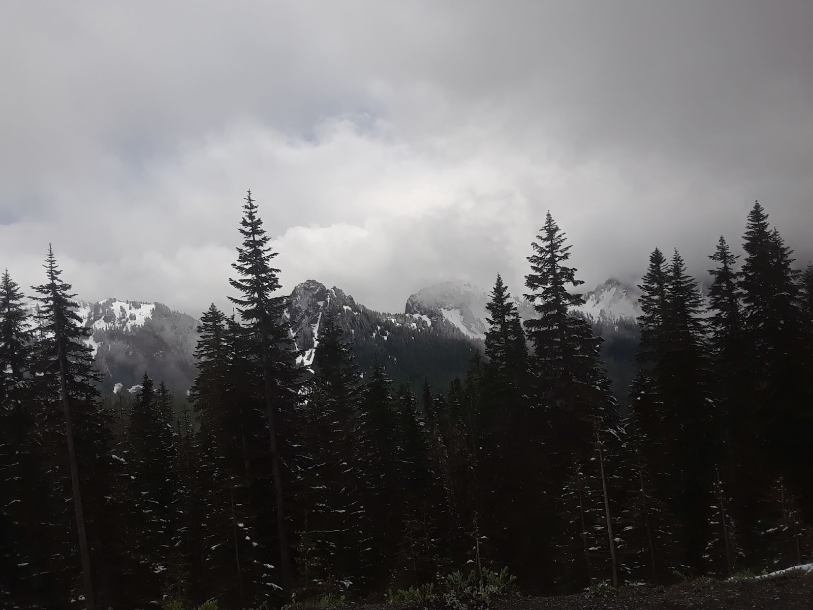
6/7- Took back roads into Mt. Rainer NP. That was my only bad call of the trip. Part of the road was unpaved and windy and if it had been only 5 degrees colder, the precipitation would have fallen as snow. I made it safely but I say go to Yakima via the Interstate instead then cut back east to Packwood. Rainier can be spectacular when skies are clear but it didn't work out for me on this day.
 |
| Rainier |
I experienced a snowfall in June at 5,600 feet altitude. I still got some decent shots and arrived in Seattle by late afternoon where I caught a skyline view at Kerry Park and another nice sunset over the Puget Sound.
 |
| Seattle 1 |
6/8- Opened the day with a 3 miler at Myrtle Edwards Park down by the Sound then caught the Space Needle and a walk through downtown for the Mariners stadium tour.
 |
| Seattle 2 |
 |
| Space Needle |
That evening, I enjoyed a nice dinner with an old friend from the Clemson Navigators. Great to see you Beulah!

6/9- RnR Seattle in 1:57:57. The course started and ended near the Space Needle. After heading toward downtown, it was a rolling highway from Miles 2-5 then downhill to the Sound followed by mostly flat stretch by the Sound until Mile 10, which was largely uphill but manageable. Mile 11 and early 12 was a KILLER. We gained over 300 feet of elevation in about 1 Mile, which equates to about a 6% grade pretty much all the way. I along with most people around me employed a walk/jog strategy. The corresponding downhill was even steeper so I didn't gain much time back because I had to brake to stay in control. Pace was pretty steady around 8:40 through Mile 10. I was at 43:30 at Mile 5 and just a hair above 87 at Mile 10. Energy was fading but I was in control and figured that I could hold a 9:00 pace the rest of the way, which would bring me home right about 1:55 flat IF the route was flat. The hills cost me almost 3 minutes but it was still a 1 minute improvement over Rhode Island last month. Caught a flight to Denver and drove to Estes Park at the edge of Rocky Mountain NP.
6/10- Drove Trail Ridge Road to Grand Lake then US-40 back to Denver. Late Spring and early Summer is definitely the best time to visit here with the snow capped peaks. Got back to Birmingham by early evening. Back to reality now.
 |
| US40 |
 |
| Trail Ridge |
Final thought:
Truly an EPIC road trip! Anything that should have been done differently? I'd take more of the Interstate down the coast in Washington and avoid the back roads to Rainier. If possible, be flexible with your plans in Seattle and choose a clear day to visit Rainier NP. Olympic NP is too far out of the way and would have required an extra day.


No comments:
Post a Comment